Aerial Imagery
Navigating Norman Creek: Aerial Imagery from 1946
The story of Norman Creek has been, and remains, one of dramatic change. One of the most valuable records of Brisbane’s history is the set of aerial photographs taken in 1946. These are among the first aerial photographic records of Brisbane, and they cover almost all of the Brisbane City Council area. The 1946 imagery of the Norman Creek area is shown below

The original photographs are held by the Brisbane City Archives, but the easiest way to access them is via the Brisbane City Council’s Planning and Development Online website, where you can explore the imagery via an interactive map.
This page offers a different view of the 1946 aerial imagery. It shows what the imagery looks like when it is loaded into Google Earth.* The series of images below have been chosen to highlight how specific parts of Norman Creek and its catchment have changed since 1946. Hovering your mouse cursor over each image (or if you are using a mobile device, tapping the image and then the white space around it) will reveal the present landscape, enabling a closer look at how individual features have changed.
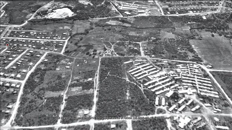
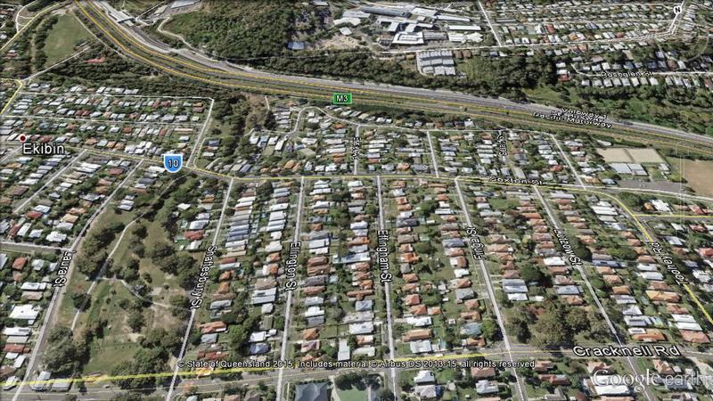
The first image below shows the upper part of the Norman Creek catchment. In 1946, much of Tarragindi in 1946 was undeveloped, and the Pacific Motorway did not exist. Nor did the reservoir on Weller’s Hill. Near Wellers Hill, the Ekibin Hospital can be seen. It was set up as American military hospital to treat soldiers with shell shock and later run by the British and Australian military. After the war, and therefore probably at the time these aerial images were taken, it was used to house a category of European migrants known as ‘displaced persons’.
This image also shows the grid of roads that would become the subdivision containing the streets from Shaftsbury Street to Lutzow Streets in Tarragindi. In this part of Brisbane as in so many other parts of this and other Australian cities, the period after the second world war was a key period of publically planned and funded house building, after a hiatus during much of the 1930s and the war.
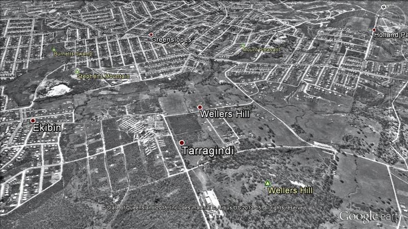
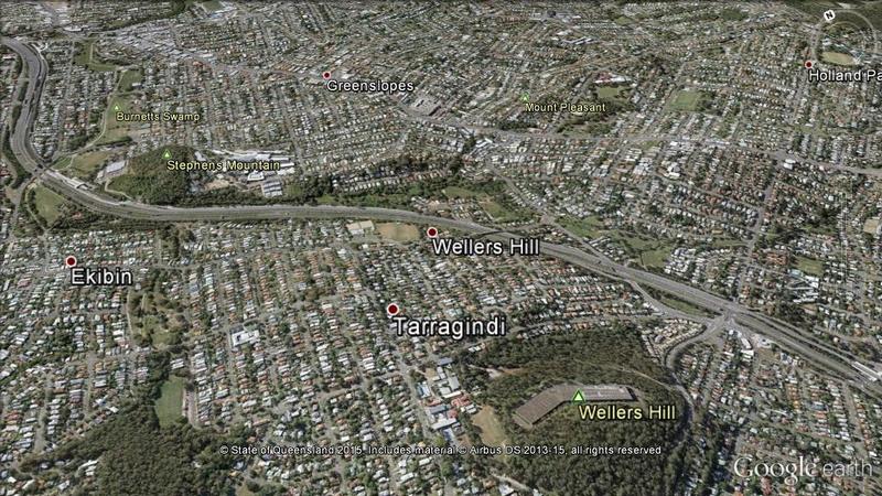
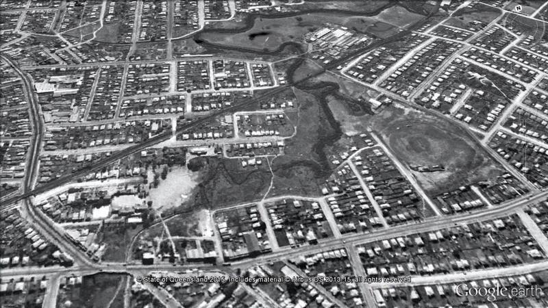
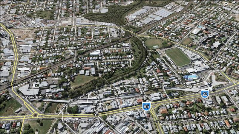
Also visible in this image, and shown in more detail in the image below, is the location of the woolscour, tannery and fellmongery owned and run by wool merchant and businessman TB Stephens on Norman Creek for around twenty years from 1856-57 till after Stephens’ death in 1877. At its height it is said to have employed around 200 people. Its location was around where Sunshine and Essie Avenues are in modern day Tarragindi, close to the South East freeway and Stephens Mountain.
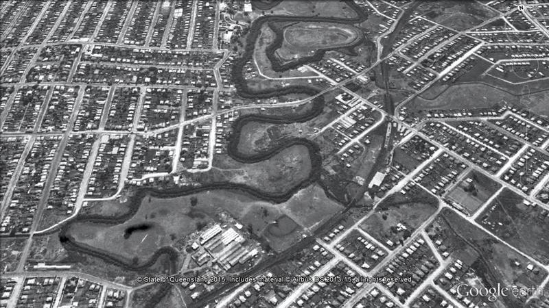
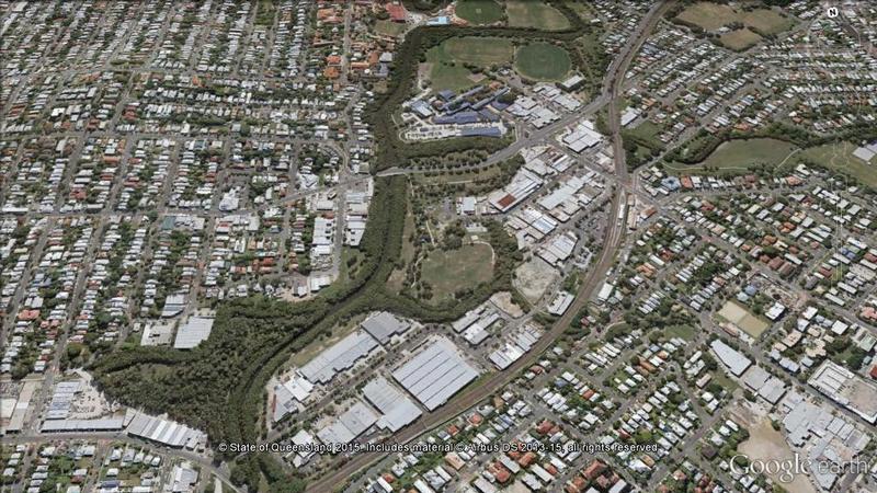
The next image shows the area around Greenslopes Hospital, including Arnwood Place and the parkland that was once Burnett’s Swamp. In the 1839 survey of Norman Creek by James Warner, Burnetts swamp is shown as a wetland rather than a single watercourse. In 1924 the area was designated a recreation area which led to some subsequent draining of the swamp. The building of the south east freeway in the early 1970s, during the time that Clem Jones was Lord Mayor, was the impetus to change and straighten the course of the creek, at the same time bringing in a lot of ‘fill’ and creating the playing fields that today typify this part of the creek and its catchment.
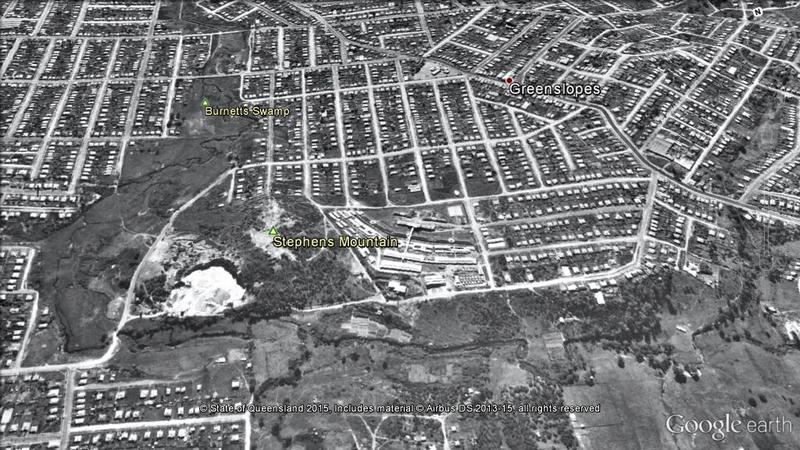
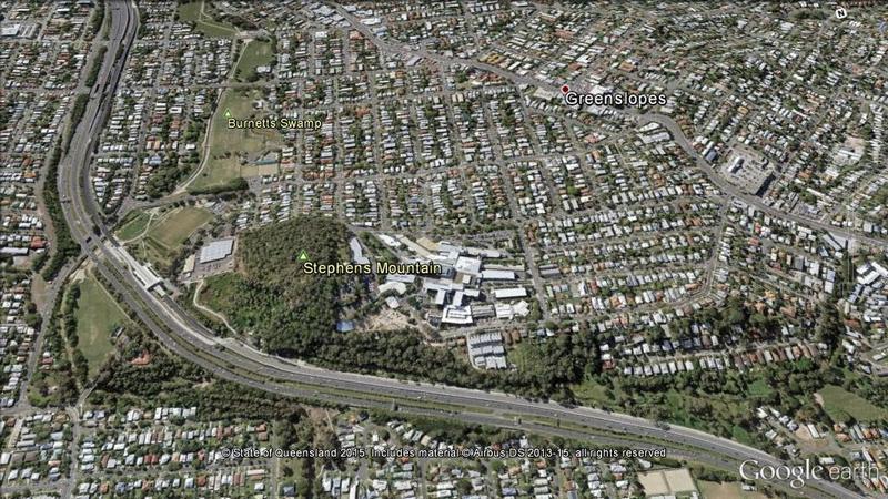
Also visible in this image is a quarry breaking down one side of Stephens Mountain. This was a quartzite and road base quarry that was in active use from the 1880s until the late 1960s. On the other side of Stephens Mountain is the Australian military hospital that opened in 1942.
The next image shows Old Cleveland Road in the foreground and Moorhen Flats in the distance. It shows how the creek has been straightened, with many meanders and sharp bends bypassed. This happened in the early 1990s after many years when the Brisbane City Council, a developer trading as Turbo Investments and local activists engaged in debate about the future of that part of the creek.
Moorhen Flats can be seen more clearly in the image below. In 1946 the flats were entirely clear of vegetation, and in the middle of the flats there was what appears to be a small lagoon. Hovering over the image reveals how revegetation efforts have transformed this piece of land. The closing down of the Malleys factory and the pushing through of the channel between Deshon and Stanley streets created the land that became Moorhen flats after a huge and ongoing community restoration job under the auspices of the Creekfreaks of the Norman Creek Catchment Coordination Committee. Today there is much light industry along Deshon Street, backing onto Moorhen Flats, which appears to be almost entirely absent in the 1946 image.
This image shows how the creek’s path has been straightened not just past Moorhen Flats, but also downstream towards Stanley Street.
Where Coorparoo High now stands, built in the late 1950s, it is clear that a small tributary of Norman Creek has been piped underground. The remnants of a racetrack on this site can be seen. It was once owned by John Wren, whose life and work was famously fictionalized by Frank Hardy in Power Without Glory (1950). This site also spent periods as a rubbish dump and as an informal football practice field.
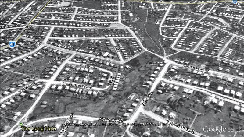
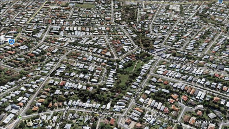
Kelsey St and the Long Hole, on the Bridgewater Creek tributary of Norman Creek, are shown in the image below. As can be seen in the 1946 photograph, the Long Hole was an ephemeral billabong that would come up whenever there was a lot of rain in the catchment and as a result a smaller but still substantial area of channelized creek has been left without permanent buildings upon it. Dave Carey, a resident of this area in the 1930s remembers these billabongs as home to rich bird and insect life. The density of trees and plant life visible along the historic course of this creek shows remnants of the original ecology still visible.
Heath Park, East Brisbane has barely changed, though it now contains many sporting facilities not visible in the 1946 image. In the early 1940s Heath Park was briefly used by the American Army as an anti-aircraft facility. As part of this, American army officers took over a number of the houses in Hilton Street, facing Heath Park. (If anyone reading this has documents or memories relating to this, please contact Trish FitzSimons on ua.ude.htiffirg@snomisztif.t.)
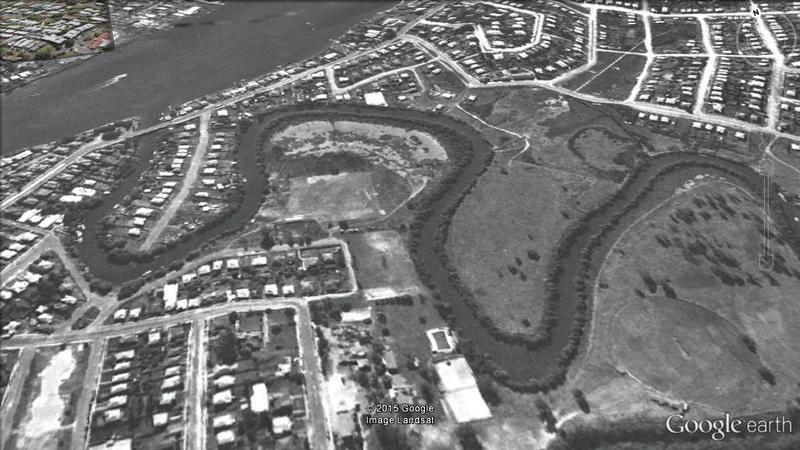
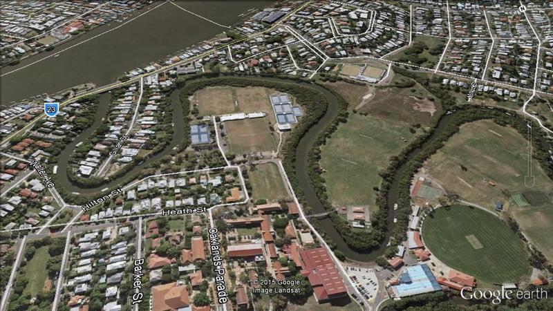
Adjacent to Heath Park the huge development of the physical infrastructure of Anglican Church Grammar School can be seen. The school moved to its current East Brisbane site in 1916, but for many years had a much smaller footprint on the land than is currently the case.
Composite images by Angus Veitch. Text by Trish FitzSimons and Angus Veitch.
*The 1946 imagery is not currently available in a format that can be loaded directly into Google Earth. The images that you see on this page were developed by first stitching together screenshots from PDOnline, then using mapping software to add geographic coordinates to resulting composite image, which was then converted into a file that could be opened in Google Earth.
Last modified on Sunday, 08 May 2016